Transformation of a Former Railway Segment in Vienna, Austria, with strategies for integrating biodiversity in limited urban spaces
Master Thesis Project 2024 | Technical University of Munich
Chair of Landscape Architecture and Transformation | Prof. Dr. sc. ETH Zürich Udo Weilacher
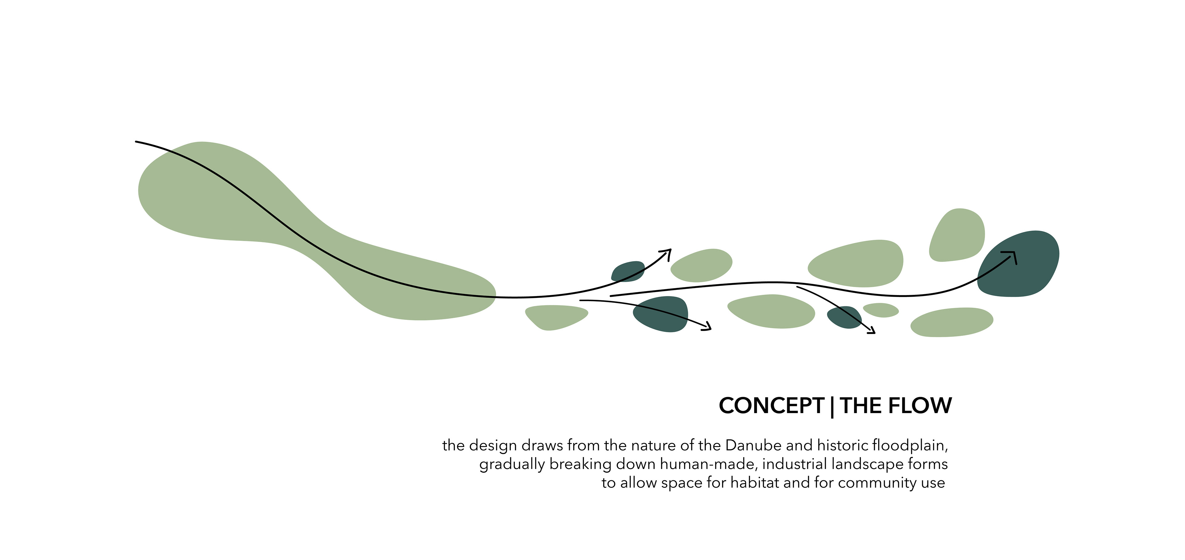
The landscape of the city of Vienna, and most pronouncedly its twentieth district between the Danube and the canal, is a composition resulting from a balancing of two forces: the river, and the the human inhabitants. Struggles between floods and regulation attempts have shaped the urban layout over centuries. Today, the meandering arms of the Danube through its floodplains are formally constrained, and much of the biodiversity in this notably rich landscape has been severely negatively effected through regulation of the river, development, and pollution. Two historical characteristics—the floodplain landscape and the flourishing industry rooted in the landscape—are drawn upon as the basis for the design of the green space which is to replace the former railway terminating in the Nordwestbahnhof.
The northernmost areas, segments E and D, are dominated by heavy traffic pollution, making them less suitable for use as green space to stop, rest, and play. For wild users however, these areas are optimally situated nearest to the river and the more biodiverse Danube Island—a benefit for flying species and pollinators with a wide enough foraging range—and are least disturbed by humans and pets. Tightly enclosed between residences, private gardens, and the backside of sports facilities, the second to northernmost segment is also ill-suited for extended human use, and it serves mainly as a connecting element with some restful seating spot options. Both of these segments are therefore intended predominantly for wild users. The urban wilderness character is most pronounced here.
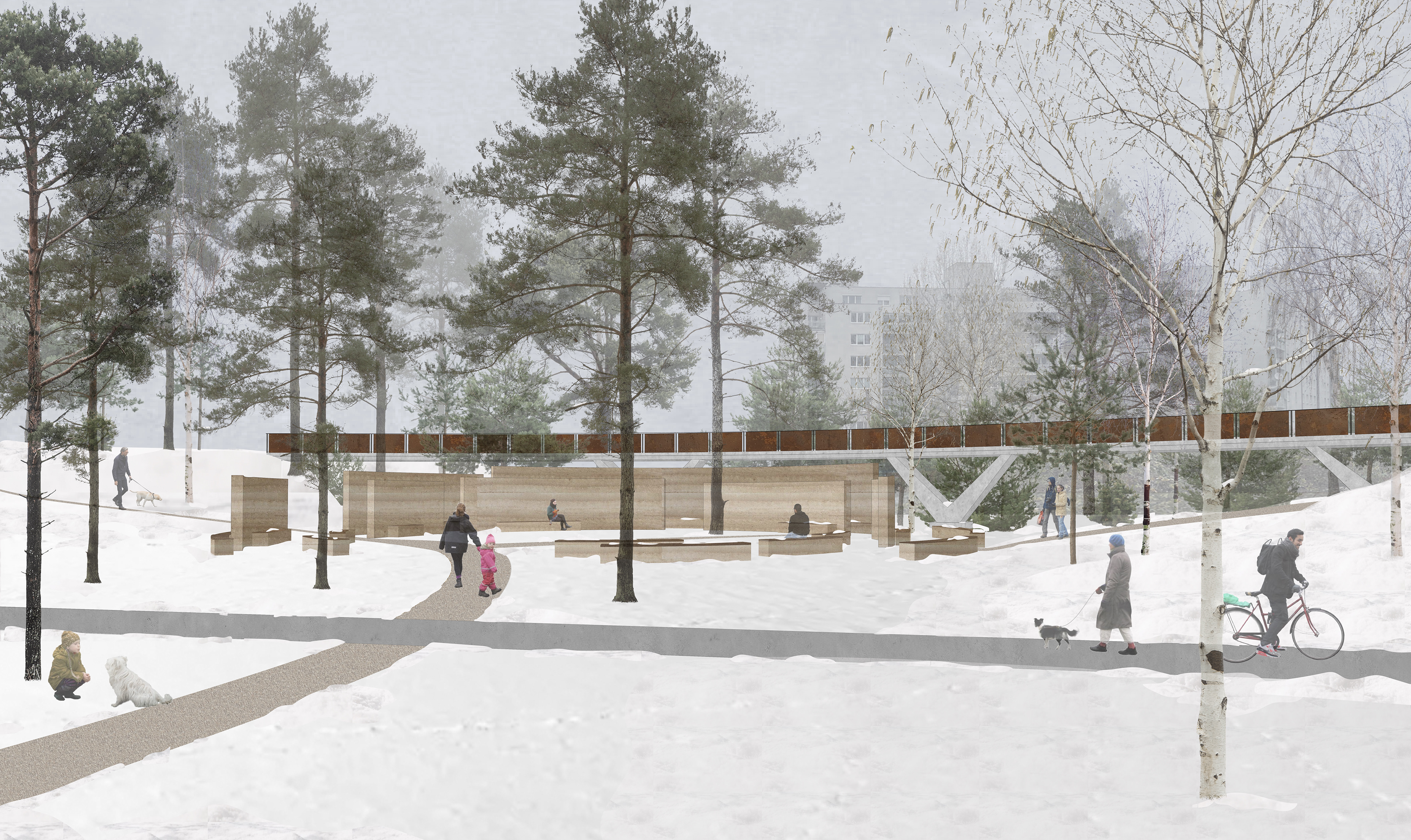
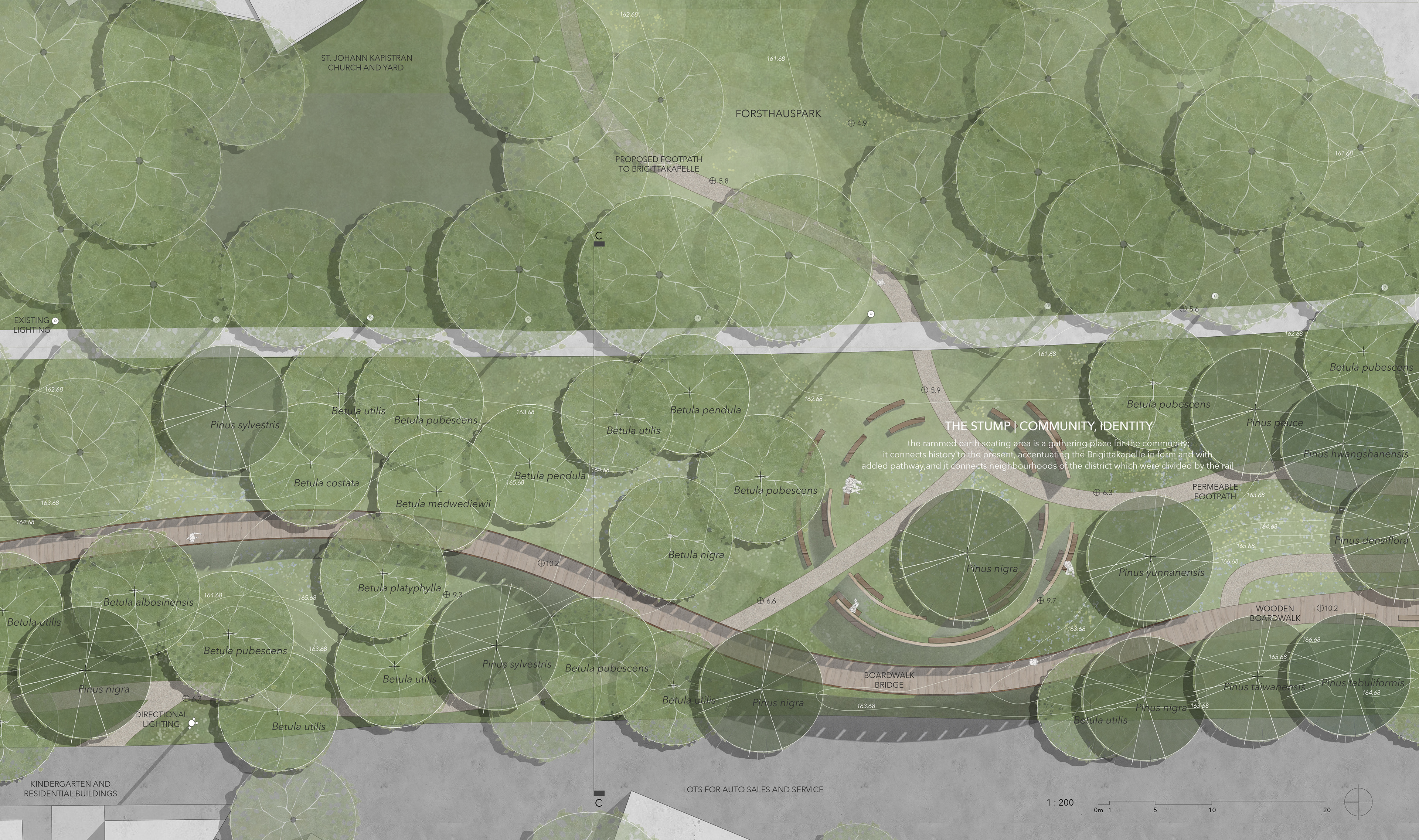
Travelling south, segment C has the most set context in terms of existing development. Between park, residences, and kindergartens, this segment is ideal as a human user dominant zone. In response to the context, this segment is the most extensively designed. Both its new built elements, as well as its more extensive working of the topography and its choice of pine-dominant vegetation, make the linearity and geometry of this area stand out from the others and bind it to its historic neighbours.
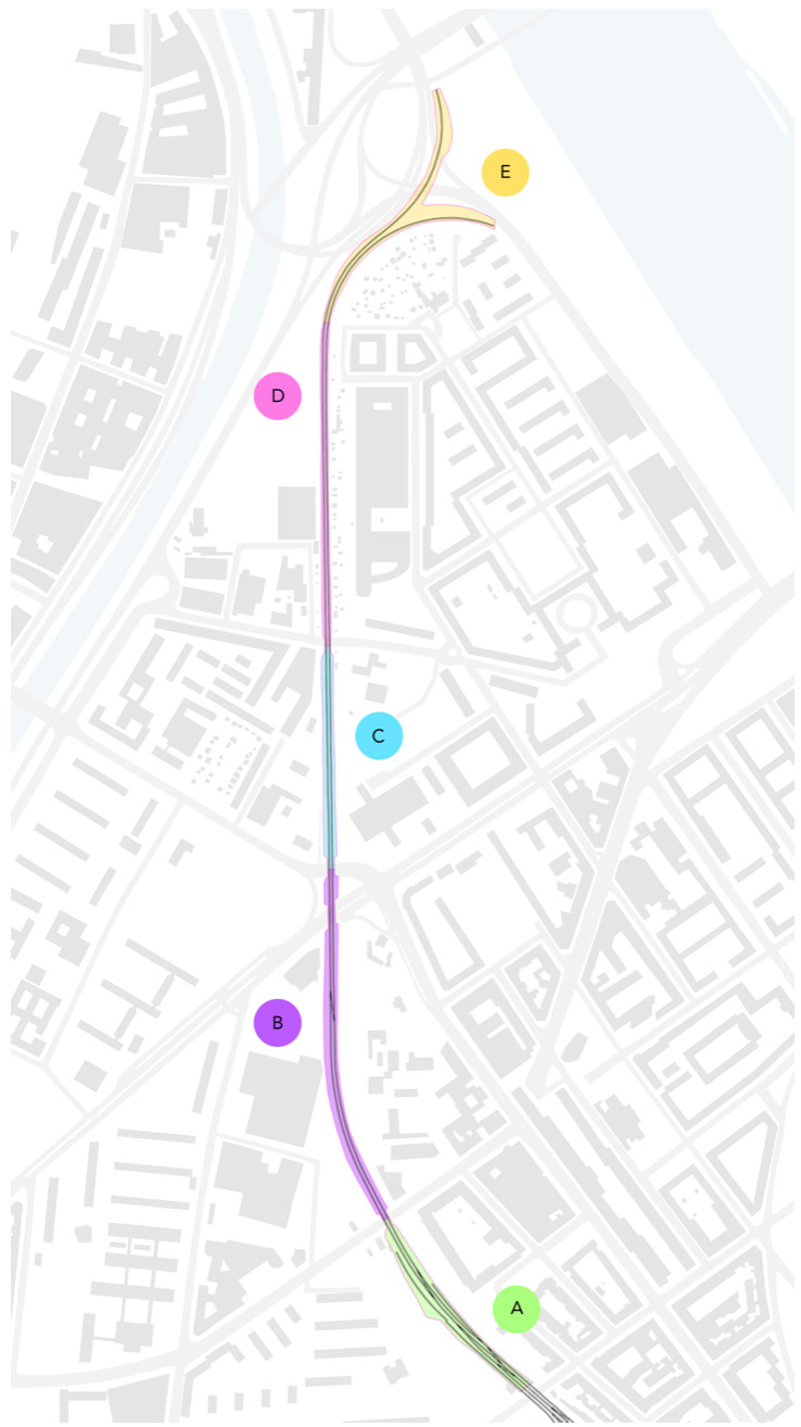
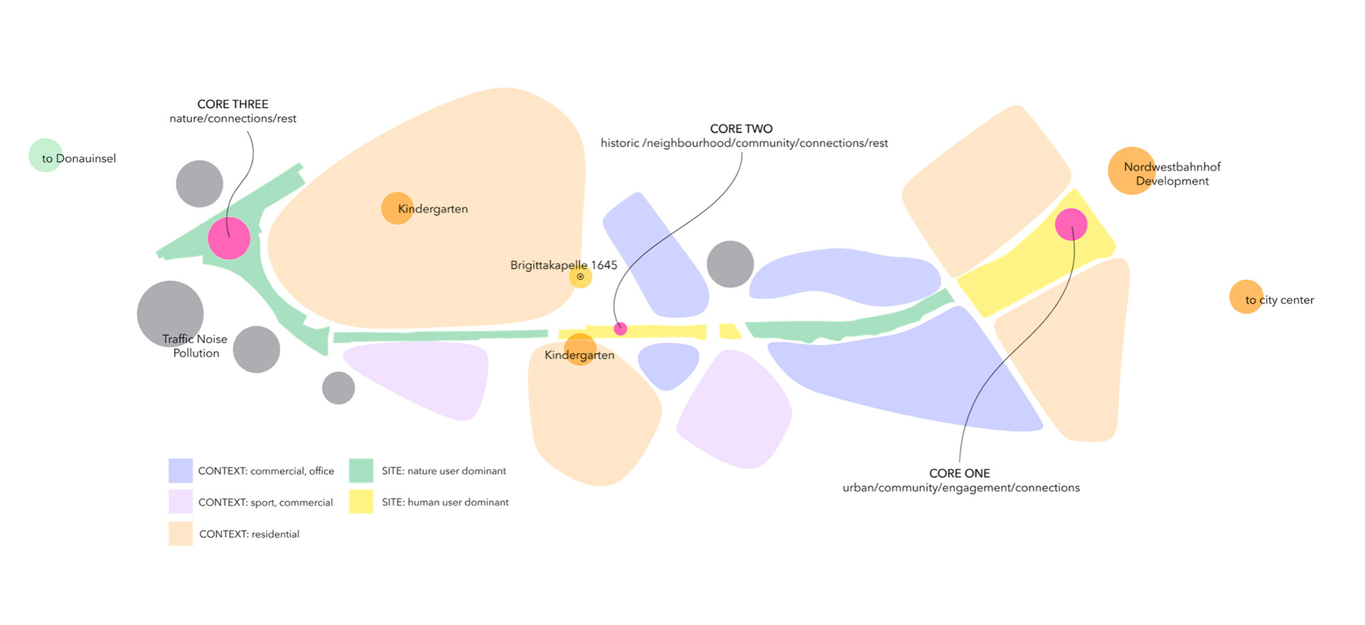
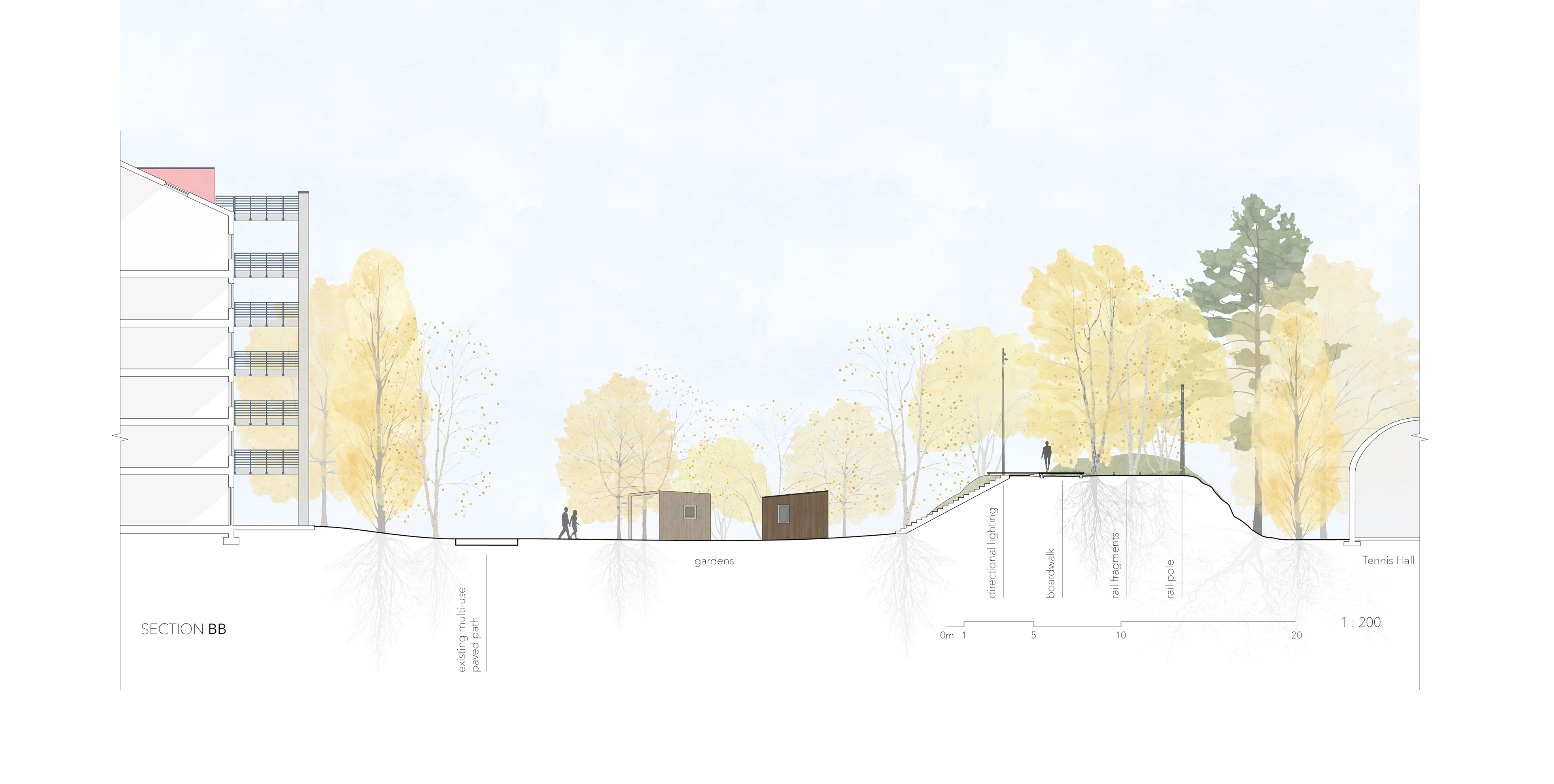
Segment B is the most highly open to future transformation and the most currently chaotic in context. Bordered by vacant lots, car sales and repair lots, some offices, the commercial loading areas, and shopping buildings and their parking lots (from the rooftop parking of Hofer one stands level with the railway), this area prioritises wild habitat as the dominant spatial use, capitalising also on the topographical low point and adjacent impermeable surfaces to construct a rainwater retention based wet woodland.
Segment A, the southernmost portion, is surrounded by an area urban and active in character, and it responds by acting as a green space predominantly intended to serve the human community. Still, the concept of this segment as an individual park, and as the summation of the entire project site as its urban core, is the engagement and merging of human and wild users. The broader area of this segment allows for more opportunities to integrate ecologically rich areas alongside those accessible to humans, and it is the goal of the design in this segment to maximise that opportunity, accentuating interaction and closeness with nature as its defining quality.
Three cores of the site anchor the design and reflect its central aims, each featuring a circular design element of varied character to emphasise the unique qualities of its context and linked designed area. Each core circle articulates the priority of heightening engagement and connection with nature in the urban landscape through a different approach. The formal language of each reflects these ideas and supports different kinds of engagement from the human users, whether through observation, through contemplation and atmosphere, or through direct physical immersion and play.
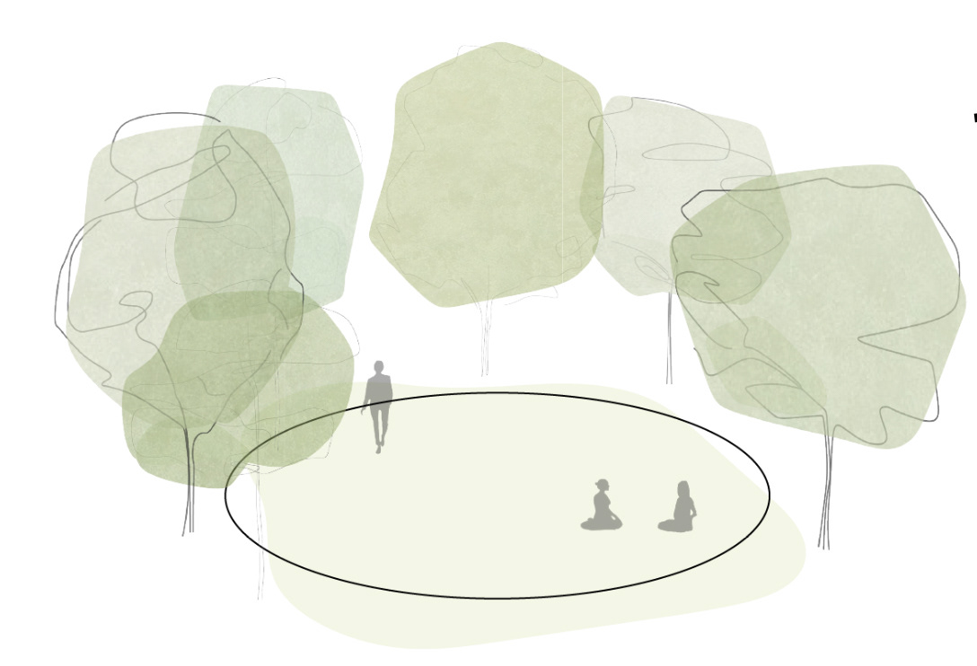
CORE ONE | URBAN This active area features the main entrance and connects directly to happening areas, and the planned mixed-use development at the former Nordwestbahnhof, as well as to nearby transportation or foot connection to the city center. Here, an active urban park is created, but an integration of the urban and wild user spaces is also brought to culmination at this place of engagement. The circular element of the urban core is a seating and gathering area made of recycled concrete. The intended atmosphere here is a playful one, and this entire portion of the site is centered around active, physical engagement with the varied natural areas, around play, and around learning.


CORE TWO | THE STUMP: RESIDENTIAL, COMMUNITY
The Stump is a built element which effectively serves to emphasise place and history, to create connections, and to afford spiritual, restful connection to the atmosphere of Forest. Conceptually, the Stump is highly representative of the project’s intent overall: to connect people with each other, to connect people with nature, and to promote the acceptance of natural growth and decay cycles as something beautiful and healthy within the green spaces of our urban landscapes.
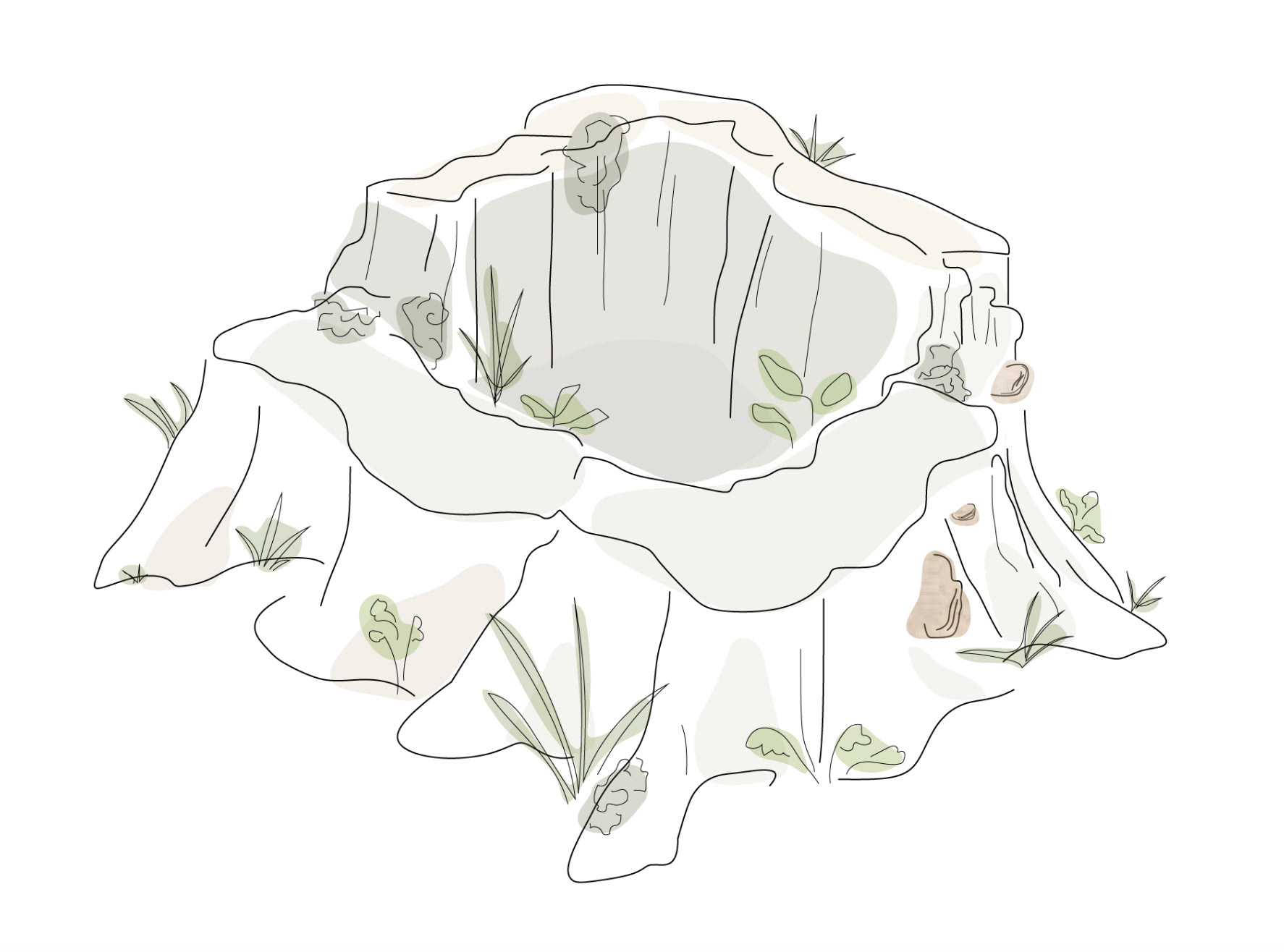
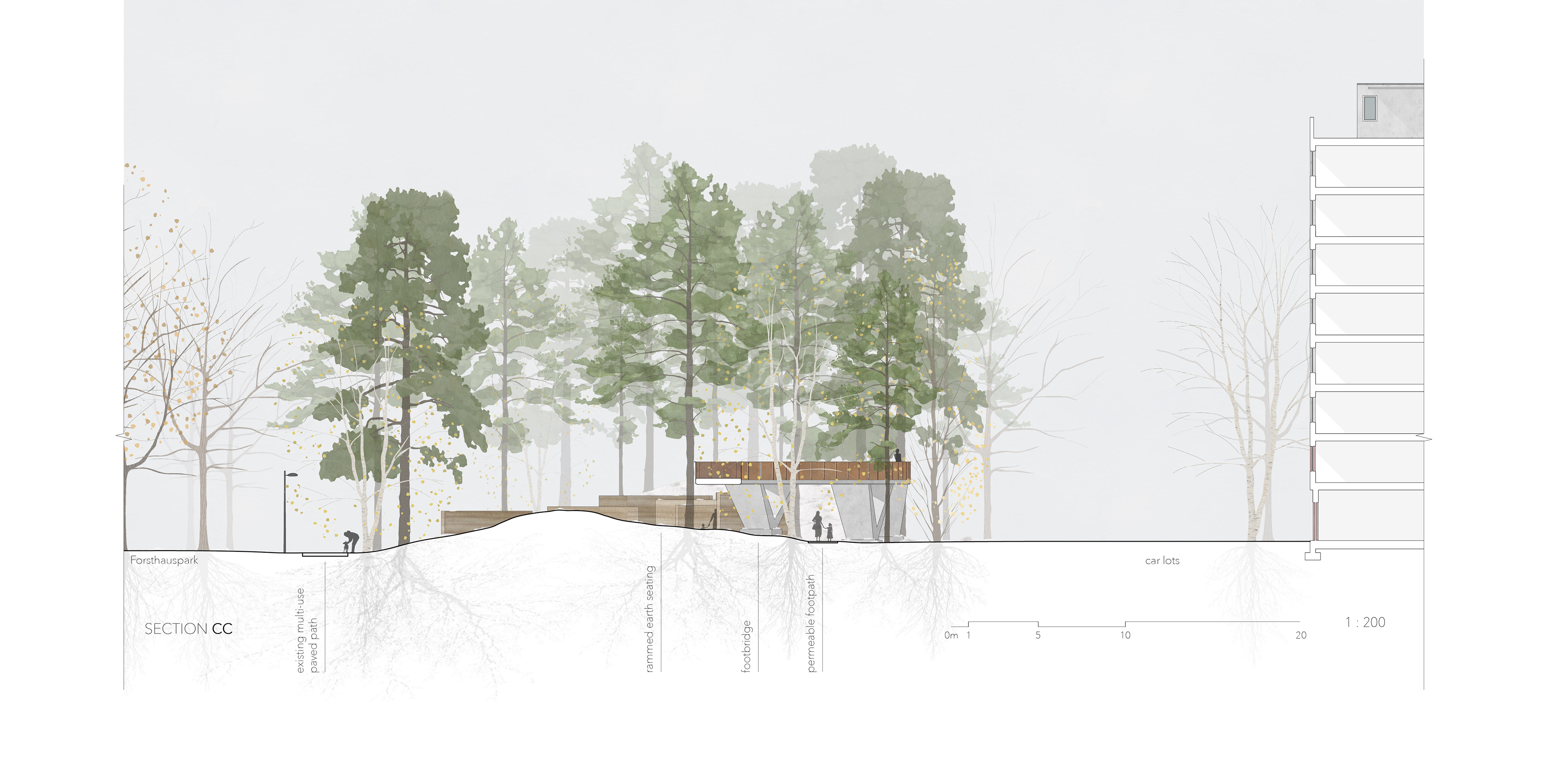
The Stump, and this segment of the site overall, is more extensively designed to reflect the character of the context area, whose development is more stable and features the most historically significant structures. The circular form acts as an element which brings people together while offering a spatial anchor. It responds to and accentuates the presence of the historic Brigittakapelle on the other side of the Forsthauspark, which provides play areas, space for dogs, and a skate park.
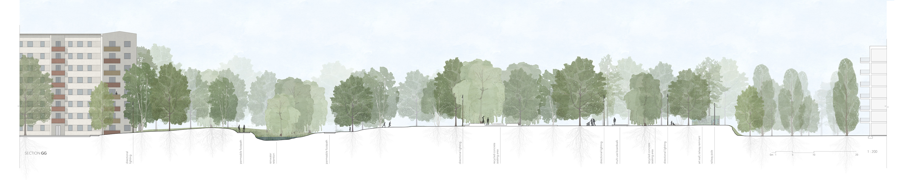
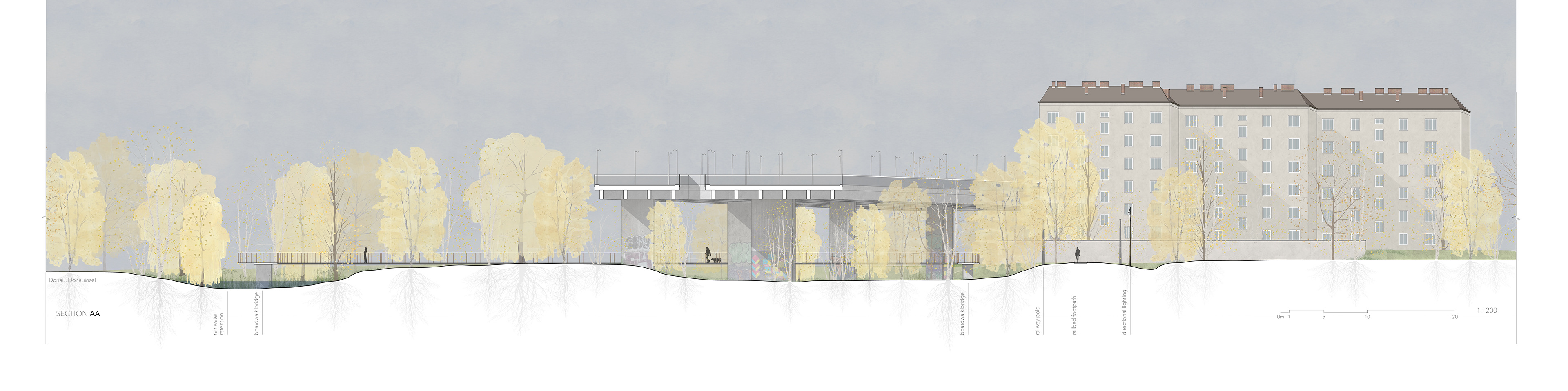
The vegetation here is dominated by pine trees. This decision is based on multiple needs of the location. Tall buildings in multiple places, such as the massive insurance office tower at one end and the residential building at the other, tightly squeeze the site; tall, evergreen trees provide visual privacy for both park users as well as those in the buildings all year long. (See fig. 55) The horizontally dominant linearity of the built elements, the Stump and the footbridge, are emphasised against the contrasting, equally strong vertical linearity of the pine trees. The simplicity and clarity of the built elements highlight the quality of Forest. The trees add, in return, through contrast, definition and a peaceful, balanced atmosphere to the built features.

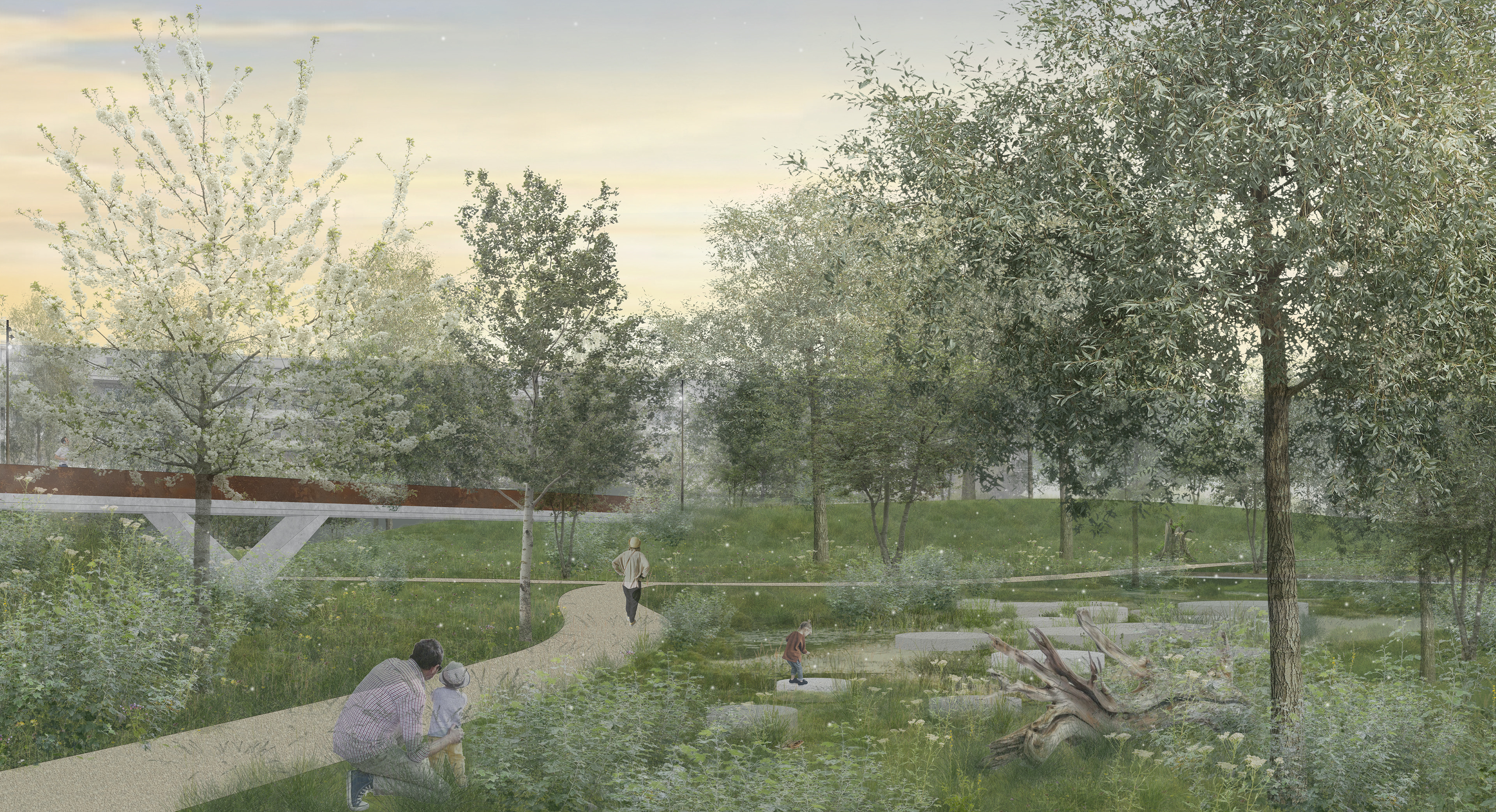
CORE THREE | URBAN WILDERNESS Near the Danube, the landscape under the overpasses acts as a buffer and connecting zone for neighbouring residents. For wild animal users, this is the central area of the design. Patterns of existing vegetation, discussed in greater depth in the following section, are built upon to create a wet woodland habitat rich with native species that support local fauna and pioneer vegetation that revitalises and strengthens soil quality. The circle element here is a raised wood boardwalk that loops under the highways and provides users with visual access to the habitat being created without allowing direct access. The boardwalk pulls out to create seating areas. The Urban Wilderness Core is about connection with nature through observation, while minimising direct human and pet disturbance of habitat in the most protected and expansive urban wilderness area.
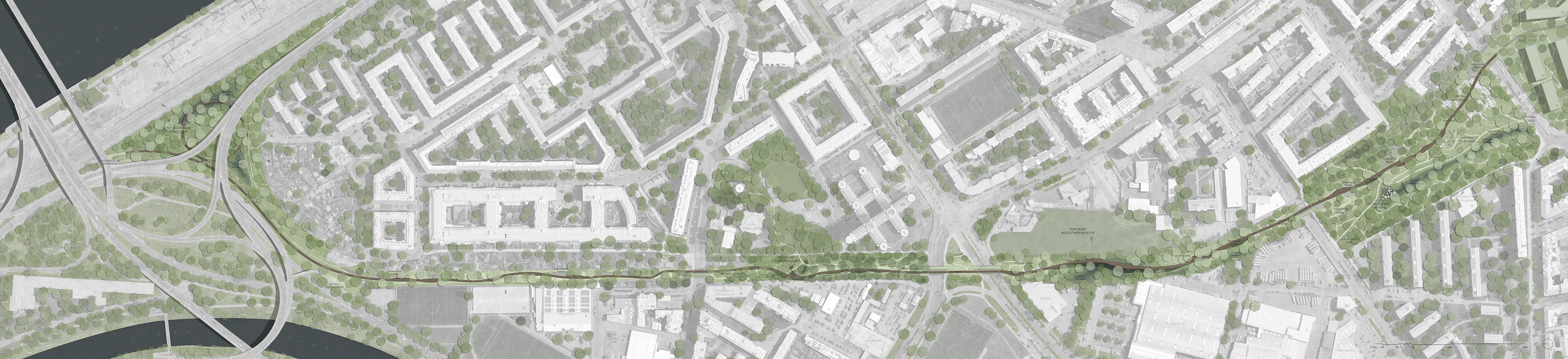
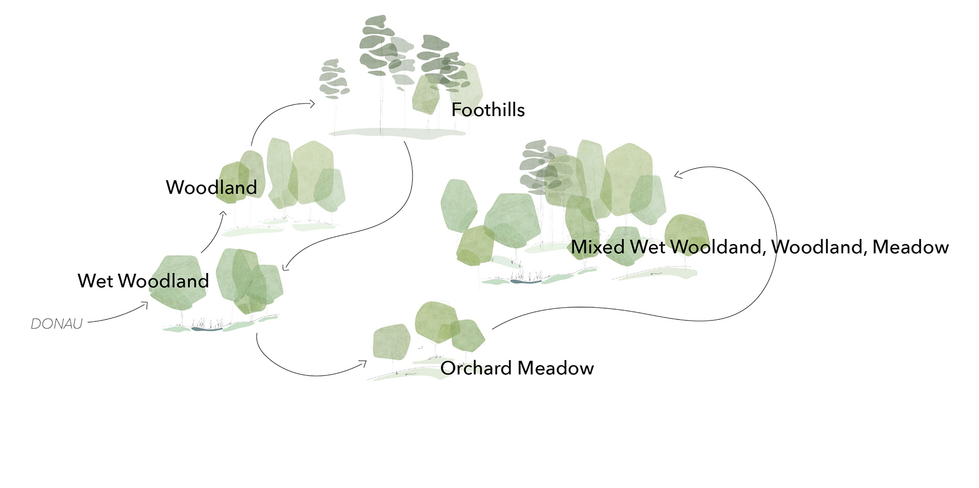
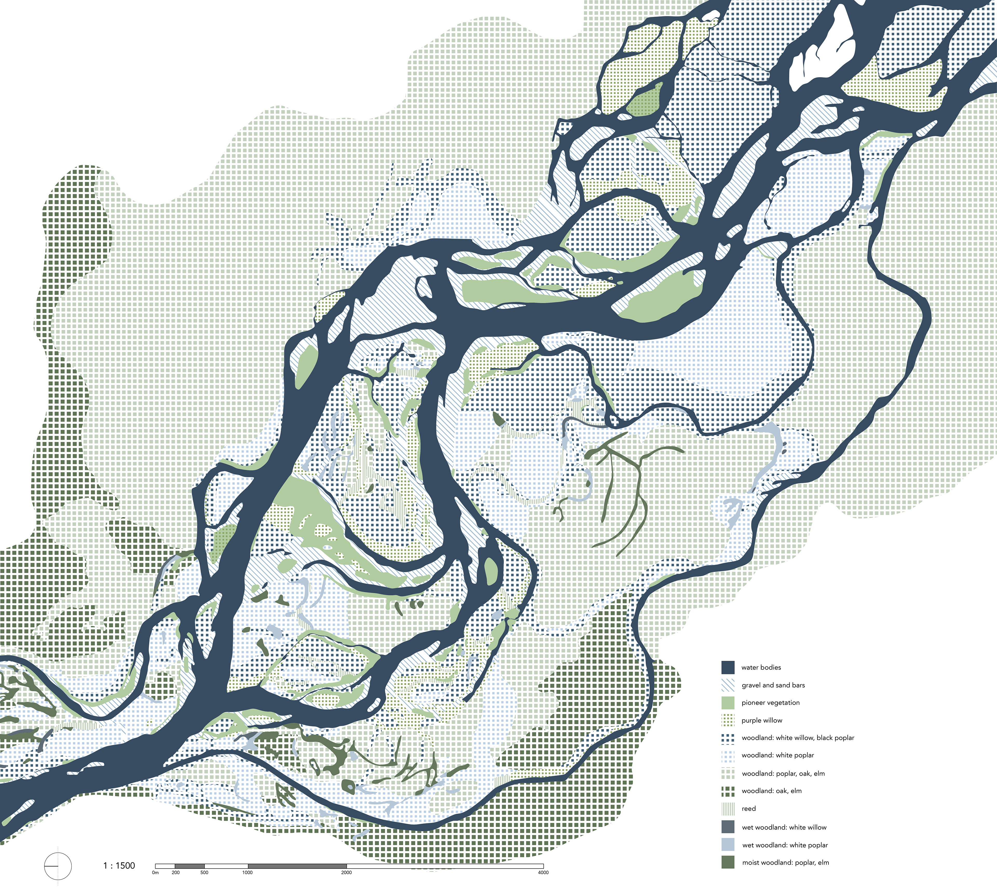
VEGETATION STRATEGY The overall vegetation strategy abstracts the greater landscape of Austria to tell a story and root the design in its specific place, simultaneously building a connected habitat system which revitalises growing conditions. The placement of each vegetation group type is closely determined by context and existing site conditions. The initial plantings in the formation of habitat areas are intended as the beginnings of processes. Ideally, succession would take place as the pioneers improve the soil and the natural areas would continue to design themselves, to merge, and to expand. The experience of travelling through the entire site is made continuous not only by the consistently present and recurring built elements, such as the boardwalk and bridges, but also through the fluid story told by the vegetation. From the Danube at the northern end, the wet woodlands then transition into woodland, which gradates into the Austrian foothills before returning to wet woodlands again. From there, fruit tree meadows open and invite, and in the culmination point, all of these characters are integrated and direct engagement with each is encouraged.

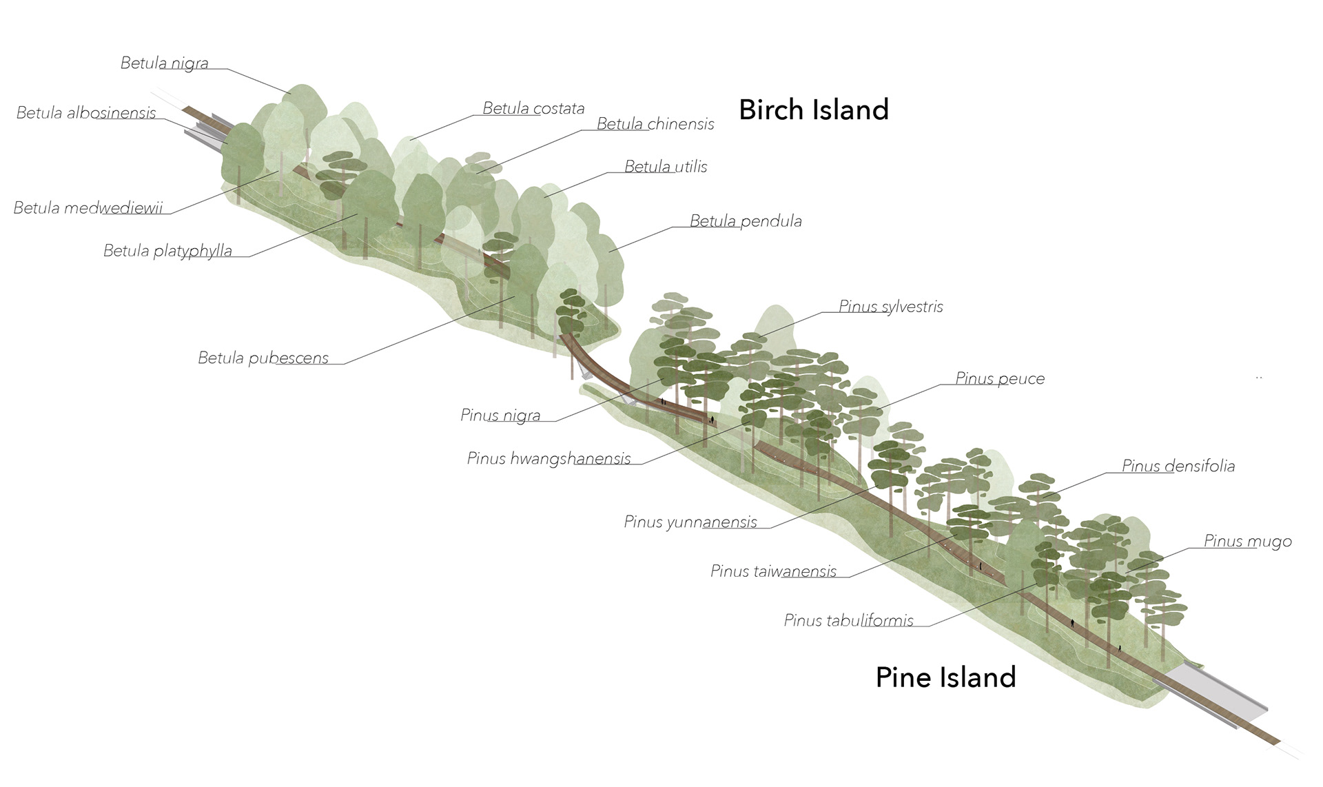
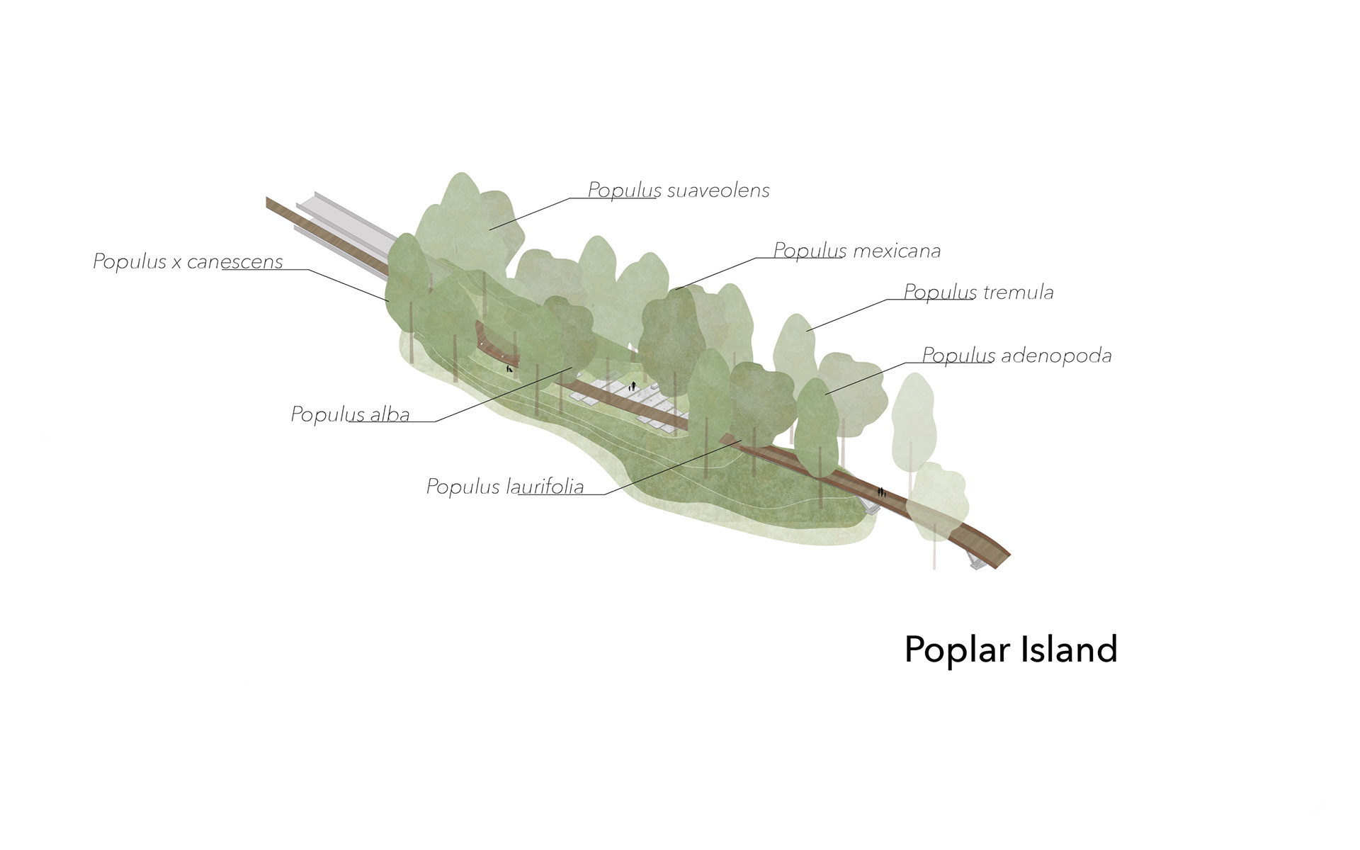
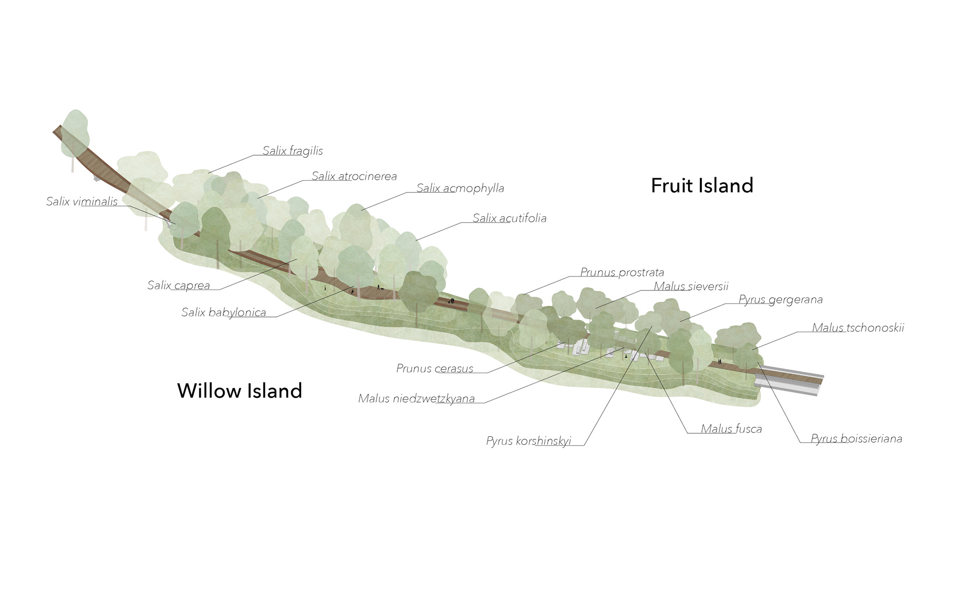
ISLANDS The urban user dominant areas within the habitat zones are conceived as islands within the flow. Like islands in the floodplain, they are formed by the flow and are not disconnected from it. The islands are meant to increase engagement of users with the nature, as well as to offer people many varied corners of restful green space to discover within the site. Each island is planted with labeled specimen trees from around the world. These are based on the dominant vegetation of a given segment. Conceptually, this connects diverse users in one of the city’s most diverse districts with their central park: everyone can find a tree that has roots where they have roots, but it’s also demonstrated how similar all these worldwide variations of the same tree species are, and how, despite the beauty of their unique characteristics, which also stand out in close proximity, they can together create a highly functional, interconnected green space network.

SUPPORTED WILDLIFE
The aim of the vegetation strategy is to create habitats for a diversity of native animal life on the site. Nesting and foraging opportunities are created for wild pollinators, and the flora supports a range of small mammals, reptiles, amphibians, birds, and insects. A representative sampling of species which could potentially be found on the fully developed new site is depicted in the figure list. The selected species are either rare and most likely to be given home on the site, particularly linked to the Danube floodplain landscape and found in the Donau-Auen National Park, and/or have been highlighted as the country’s animals of the year.

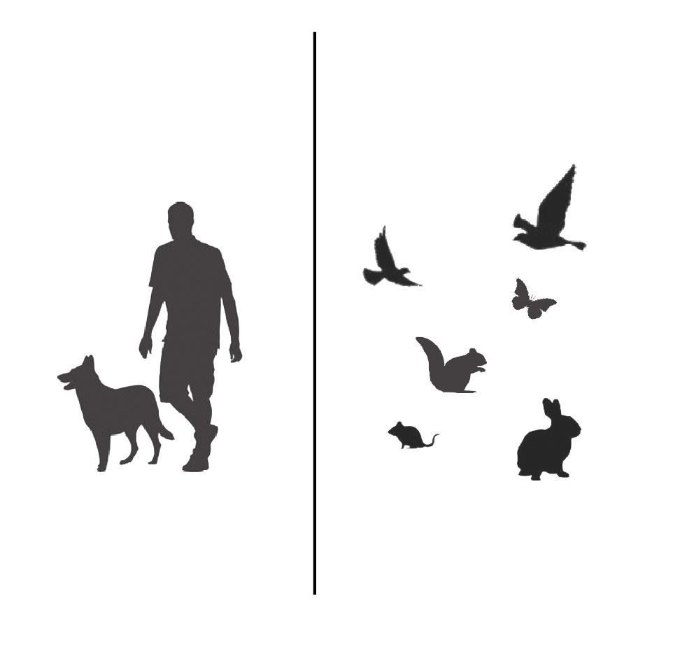
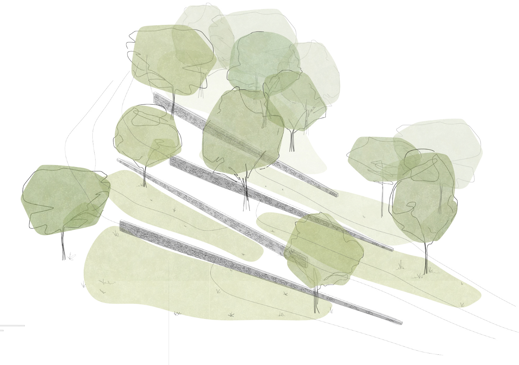
SHARED USE STRATEGIES One of the central intentions of the design is the integration of habitat and recreational green space. In some places, the two user groups can be brought more closely together, but in others, it is also critical to have areas, for instance for nesting, which are minimally disturbed by humans and pets. Through observation, more strict and heavy-handed methods such as signage to keep out of areas or fences are rarely as successful as those which simply choreograph the topography, vegetation, and materiality of surfaces to invite human access in some places and gently discourage it in others. The strategies (from left to right: bridge level separation; boardwalk circulation; drop-off bee nesting walls; dense understory vegetation; ballast and rail ground cover; and spaces for nature engagement and interaction) are applied throughout the site in order to minimise the access of urban users (people, pets) into areas where greater protection is desired for wild users (insects, birds, wild mammals, reptiles, amphibians). They are diagrammatically depicted in the illustrations below according to the reference numbers.

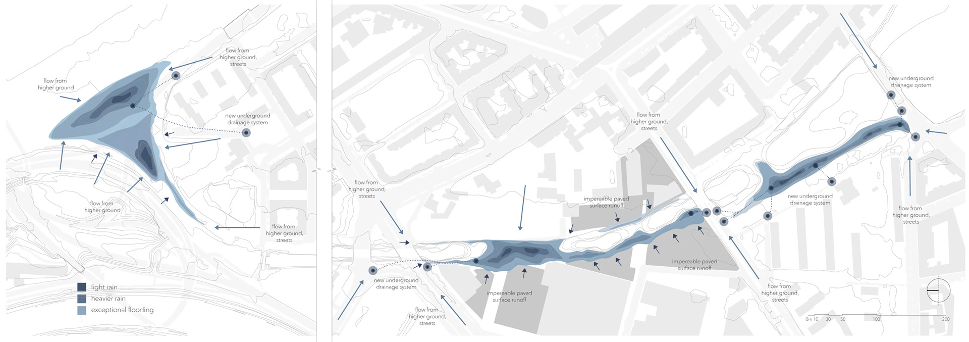
RAINWATER RETENTION Because of the historical natural character of the district’s floodplain landscape, there is a conceptual continuity in working with water on the project site as a defining quality of the new design. Practically, there are also numerous benefits: better drainage from streets in heavy rains, the creation of wet woodland habitats, and while flooding or severe rainfall events have not been major issues since the regulation work on the Danube, having areas which could serve to hold larger amounts of water in extreme rainfall events given the unpredictability of our climate’s future is not unreasonable to consider preemptively. The nature of raised railway beds, designed to efficiently shed water, to become bordered with water loving vegetation where the moisture pools, was additionally inspiring of the wet woodland centred design approach.

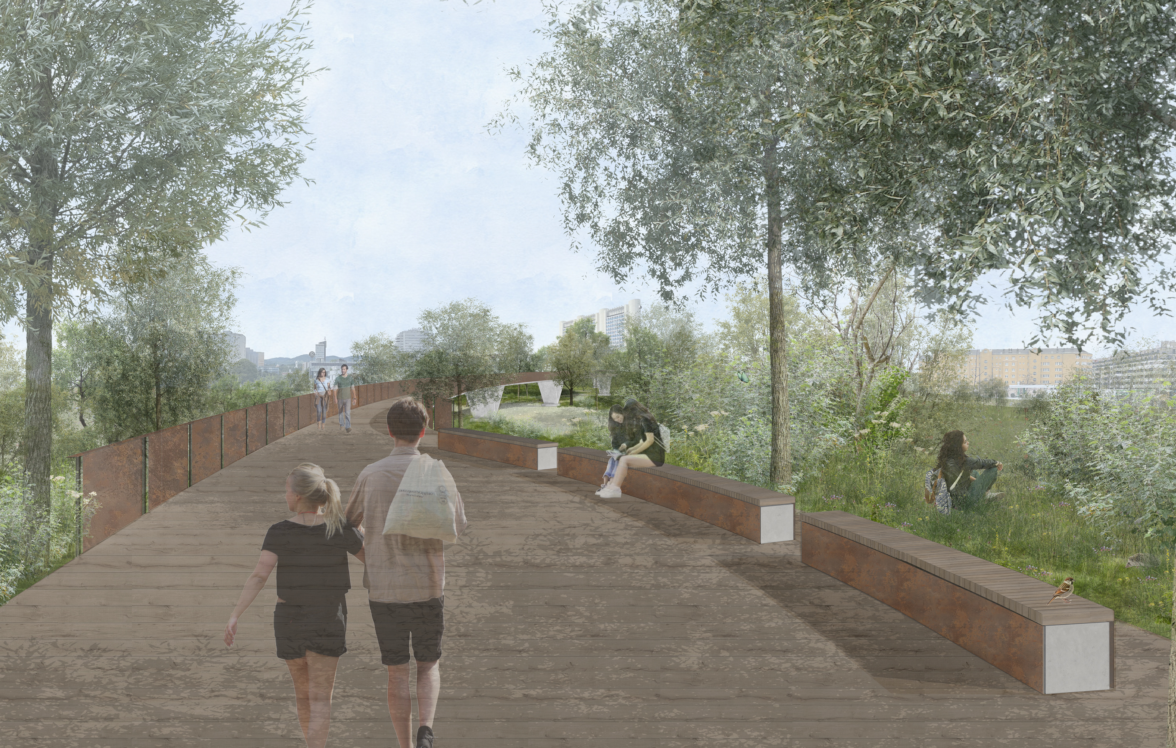
FOOTBRIDGE AND SEATING DESIGN The designs for the boardwalk bridges and the seating elements are intended to create a sense of coherence throughout the length of the site, to link the design to its urban context, to invite, through its details, engagement and inclusion of all users, and to respect the historic industrial character of the district and site itself. The materiality is simple and consistent: recycled concrete made with on-site materials and optionally, if structurally necessary in the case of bridge supports, with limestone from the mountains that has built many other structures in the city; Corten steel, and wood accents, derived when feasible from the site.

The spatial quality of Vienna could be described as a composition of contrasting counterparts. Weighty stone structures frame spaces almost too massive for the contemporary life of the city and seem to hold the spirit of an empire in the grand scale of the open spaces between solid, balanced facades. But the intricate, fine details of Jugendstil metalwork and wooden whiplash lines are rich and bold enough to contrast yet balance, and not be overpowered by, the weightier structures. This reflects the spirit of the city as well: a nuanced bohemian energy is equally present alongside the calm majesty of a former empire’s seat. The design of the built elements in this project are an ode to and reflection of this defining spatial quality of the Austrian capital city, which has long been a cultural melting pot and place of artistic exploration. The solid concrete structures, the angled supports also evocative of railway bridges, have a solid presence within the landscape.
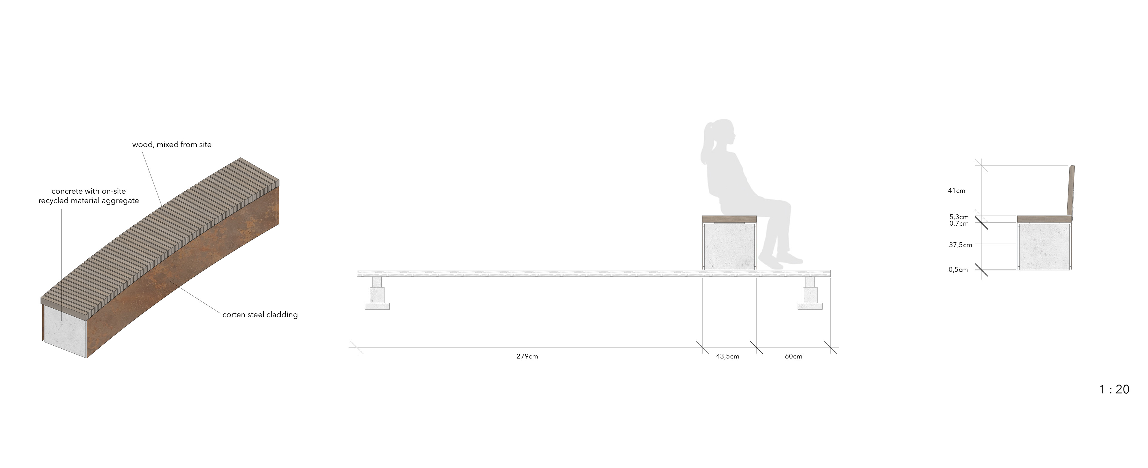
The benches continue the design language of the bridges and create a unified spatial character. Recycled concrete blocks act as the framework over which Corten steel panels are a weightless skirting. The benches are topped with wood, lain so as to reflect the railway ties rhythmically running along the tracks. Both backed and backless alternatives are presented. The backless option provides the benefit that, when placed as proposed at least half a metre from the edge of a pathway or boardwalk seating bulge, a user has the option to comfortably sit facing away from the path and the activity on it, instead being visually absorbed in the surrounding nature.
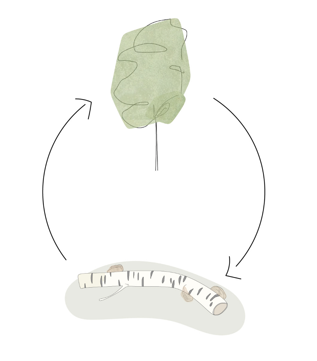
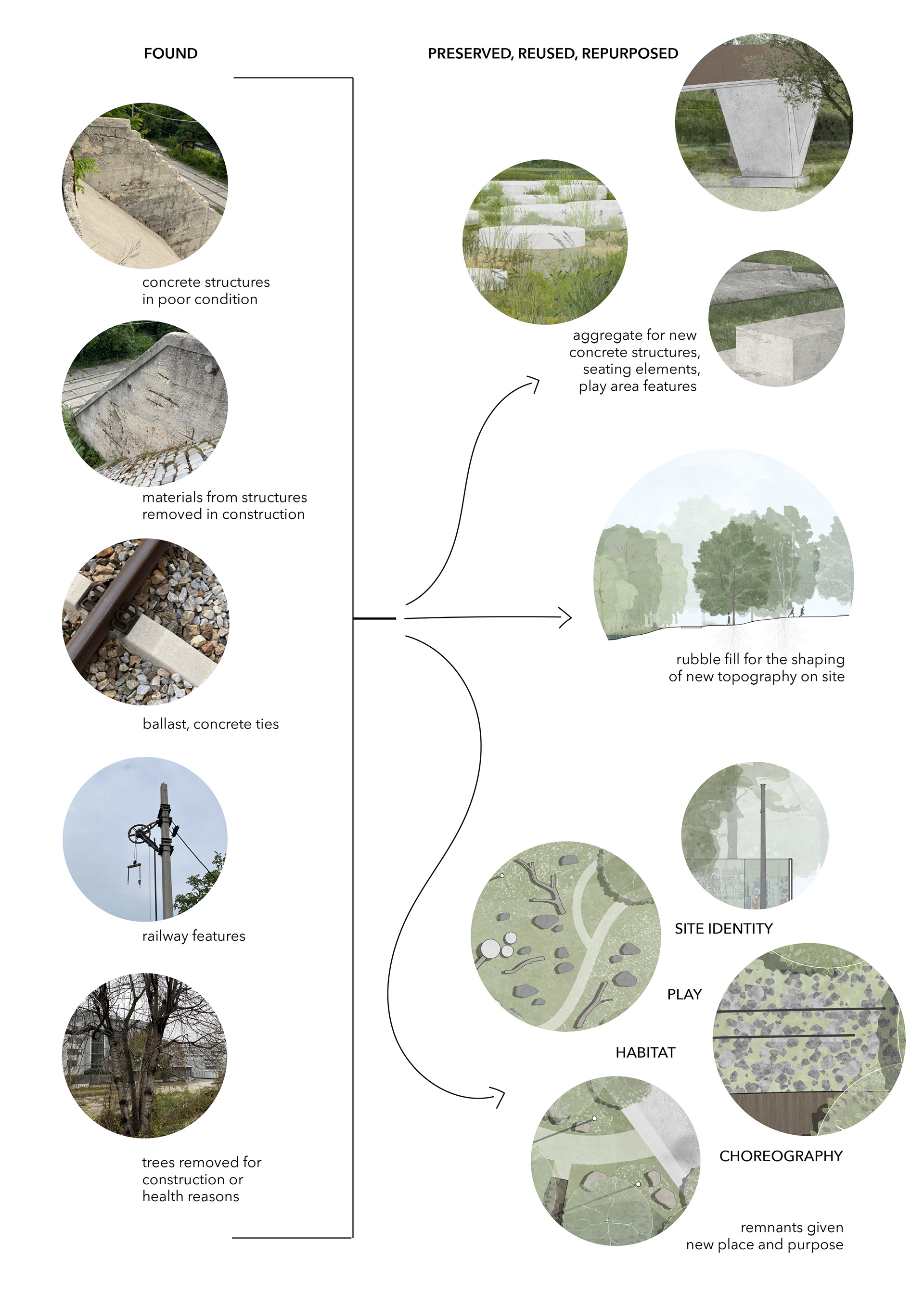
MATERIAL REUSE While the site is clearly transformed into a new character that can optimally serve its current and future community, part of that character is the strength of site specific identity found only in the aspects that have formed its unique atmosphere over time. It is the intention of this project to maintain some of that identity-shaping historic character even as a new life of the landscape takes form. Materiality is a significant quality considered in the attempt to achieve this goal. On one hand, that means using new materials that create a dialogue with the historic and place specific character.
But most centrally utilised is the method of reusing, repurposing, and preserving materials and built elements found on the site. This strategy is also brought into central consideration out of the environmental benefits of avoiding the manufacture of more new materials than necessary and of disposing of old materials, both of which have significant negative impacts in terms of sustainability.
ORCHARD TERRACE In the southernmost segment, the fruit tree meadow is an abstraction of Austria’s gently rolling agricultural lands. The dry stone wall terracing is a feature intended to provide effective and valuable habitat for many insect and reptile species for nesting or finding warmth. Its slight angle provides it with a gentle southern exposure which supports the creation of this habitat. It is also intended to reflect the surrounding vineyards that define the landscape of Lower Austria. Space is provided for resting or picnicking, the atmosphere for which is invited by this familiar structural element of the countryside. This area also provides accessible connection the the boardwalk from the street level.